Community Reimagining Pollution Data
How can Canada’s National Pollution Release Inventory be more accessible and meaningful for community members?
This project worked with community members to vision how environmental data might work starting with Anishinaabe teachings and needs.
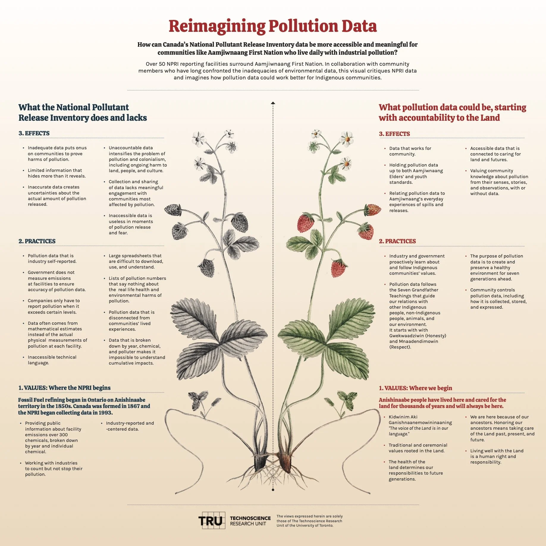
Starting with values, the project compared a reimagined Anishinaabe environmental data practice with the current federal pollution release inventory.
Pollution Data in Chemical Valley and the NPRI
Making a Visual Reimagining Pollution Data Aamjiwnaang First Nation community members are continuously exposed to spills and releases from facilities in any direction of the reserve. Community members face continuous uncertainty about the daily spills and releases, and the hundreds of different chemicals involved. The information about the spills and releases is minimal and the information about the chemicals are usually next to nothing. These spills and releases happen to take place anytime and any day. Connected to the work for Land and Refinery, the TRU’s Environmental Data Justice lab successfully linked 67 of the known chemicals released in Chemical Valley to create the Pollution Reporter App using the NPRI data. This use of the NPRI data led to a formal collaboration with the NPRI office to visualize how their information about pollutants can be more accessible and useful for community members who live so closely with many polluters.
Information that links pollution to specific companies and facilities in Chemical Valley is rare. Air and water monitors show that pollution is happening, but not who is polluting. Thus, pollution data in Chemical Valley rarely helps with holding polluters responsible for their actions.
The National Pollution Release Inventory (NPRI) is a Canadian federal program begun in 1992 that requires all facilities that pollute over a certain amount to report on their releases of some 300 plus pollutants annually. Thus, it is one of the only sources of information where companies admit to their pollution. Over 50 NPRI reporting facilities surround Aamjiwnaang First Nation.
NPRI data is published annually in a large spreadsheet and via a government website that is very technical.
There are many problems with the NPRI, including accessibility and usability for community members. We discuss NPRI, and some of its problems in relation to Chemical Valley here, and how it relates to the history of the Imperial Oil Refinery here. Despite these problems, the NPRI can be useful and we reframe this date for community use in the Pollution Reporter App that connects pollutants and their harms to polluters.
We know that pollution data can and should work better, and could begin with Anishinaabe values and Indigenous governance. Part of the major disconnect between Aamjiwnaang and the raw data the NPRI provides is that the data does not address the impacts the chemicals have on human and environmental health. Anishinaabeg traditions of how we connect always relates back to the land. Like all of creation, there's stages of growth and understanding, this should reflect how non-Indigenous organizations and “experts’ build and maintain healthy relationships with the community.
To reimagine the NPRI and community-centered Pollution data we consulted with Aamjiwnaang Community members in a series of open meetings.
Visualizing Conversations about Pollution Data
How could pollution data serve front-line communities? What would pollution data look like if it started with Anishinaabe values?
Throughout our work on Land and the Refinery, it has been important to create better information about cumulative exposures and pollution that are less technical and more useful to community members.
For this project, we made visual posters to gather and make more accessible the knowledges and insights that came out of community meetings and consultations as well as our research. We hosted multiple community meetings and also held some individual consultations with interested Aamjiwnaang community members. We invited an Indigenous visual artist to capture our conversations graphically.
Community members represented in TRU’s ongoing engagement with NPRI data includes an elder, youth, 2 Spirit people, and women. This visualization resulted from two community events, one-on-one community consultations with Aamjiwnaang community members involved with environmental data, and the collaborative work of the TRU lab, which includes Aamjiwnaang community members. One-on-one conversations allowed us to talk in more detail about their thoughts on the NPRI data. Aamjiwnaang community members have extensive knowledge of the industries and the impacts of exposure to the chemical pollutants the NPRI includes in its database and their expertise is represented in the visuals.
The visuals produced by the TRU were shared with community members for comment, editing and approval. The visual was produced in 2022, and was in part funded by the NPRI office of Canada’s Ministry of Environment and Climate Change Canada.


